Orbital Net: AI-Driven Geospatial Analysis
 Yuji Kobayashi, CEO
Orbital Net provides AI tools that are compatible with Free Open-Source Software for Geospatial (FOSS4G), offering solutions to civil engineering consultants, survey and planning companies, mapping, GIS providers, and more. "We are specialized in using AI for geospatial analysis. The results of mass image interpretation from aerial photographs are directly converted into a database of geospatial information and are further processed using big data analysis and GIS," says Yuji Kobayashi, CEO, Orbital Net. The company is developing cutting-edge technologies for aging and carbon-neutral societies.
Orbital Net's core offerings with AI-enabled geospatial applications called "Geo Detector" and "Geo-Tracer" assist in volume land tracing and wide-area calculations with short turn-around time. Geo Detector leverages deep learning's real-time objection detection technology to discover the geographic features from the aerial photographs. Geo- Tracer, on the other hand, outlines the geographic features using deep learning's instance segmentation and generative adversarial networks (GAN) techniques, which depend on the features of the geographic information to be detected. And finally, the area is detected with a simple human judgment based on lines and polygons. Adding more to Orbital Net's portfolio, "Traffic Counter" is an important tool that measures the volume of automobile and pedestrian traffic.
The Genesis
Orbital Net came into existence as a spin-off of an IT department of a local surveying and design company. Accumulating the judgments and evaluations of engineers on the location data acquired over the years by national and local governments and infrastructure providers, Orbital Net has developed a deep learning platform that enables any town planner to interpret the information to create a better environment. "Innovations in Orbital Net accelerate the development of AI and other technologies with a long-term vision to contribute to the improvement of a resilient social infrastructure," says Kobayashi.
Kobayashi emphasizes the AI-based deciphering method that usually has satellite imagery as the mainstream target for generating maps and their elements.
We are specialized in using AI for geospatial analysis, the results of mass image interpretation from aerial photographs are directly converted into a database of geospatial information and are further processed using big data analysis and GIS
The strategy of using AI does not just limit to a detecting tool that deciphers small/medium objects accurately on a surface but is also positioned as a content generator that creates high-speed, high-volume, and precise information at once. Orbital Net overcomes the conventional methods that involve long man-hours in retrieving the data, "We respond to technology trend of satellite imagery as well as aerial photography to achieve semantic segmentation and instance segmentation," adds Kobayashi.
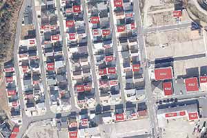
Illuminating a success story of surveying 6000 km² (square kilometre), identifying buildings with solar panels in such a vast area required a tiring effort from humans, which seemed practically impossible to finish on time. Considering this as a challenge, Orbital Net studied the information of the construction location from the aerial photographs using Geo-Detector, assisting to go beyond the PoC (Proof of Concept) of actual work and to judge whether the teacher data can be created logically and consistently. "We make decisions based on the principle in which the data retrieved can be read by a human as well as AI and it directly affects accuracy if the teacher data is logically consistent with minimal wavering," says Kobayashi. As a result, the process of extracting 250,000 rooftop PV Systems, georeferencing them, and installing the database was completed in six hours.
An AI-enabled Error-free process
Another noteworthy feature of Orbital Net that contributes toward location-based information assures three-dimensional mapping to reduce human errors. It is unconditionally fast-forwarding the business of Orbital Net by utilizing the variant deep learning datasets and simplifying the use of disseminated contents. "We use open data and AI to improve reading accuracy and create new geographies," says Kobayashi. Subsequently, many surveyors are now equipped with proliferated drones that are mounted with laser scanners and SfM/MVS (Structure from tMOtion/Multi-View Stereo) to perform 3D measurements. Since the equipment is now available at an affordable price, the amount of 3D point cloud data acquired using lasers have dramatically increased, and so has the need for software and services for efficient processing. Orbital Net is currently working on AI to streamline the filtering process of the 3D point cloud.
Excelling in the existing market as a geospatial solution provider, Orbital Net is now engaging more in developing products and contracts in phases. The first phase of progression in the business was power-packed with entrusted AI-enabled tools that have an advantage over the conventional methods of construction periods and human surveillance. As a result, it has increased the rate of receiving the orders for production operations than in the past. Orbital Net is strengthened with an experienced in-house production process through production to sales unit. And phase two is focused on bringing a shift in the industry among the competitors by developing specialized AI tools for each special operation.
Going further, Orbital Net is moving away from low-resolution generalized systems that follow conventional methods of mapping. And the company will continue to offer the services with the latest equipped devices that enable high accurate location-based readings by developing special environment-based information with GPU (Graphics Processing Unit) in the web systems. "We would like to implement the equivalent function of the geospatial product as a web service by building the environment on the user side and acquiring more users," concludes Kobayashi.